Summary
There are 11 proposed locations for Street Singing. You can see them on the map below, which is the same map as will be presented in the Street Choirs Festival Dumfries 2026 brochure. Please note that locations 1, 2, and 9 will not be being used.
Saturday, 13th June 2026 from 13:00 to 15:00
There are 11 proposed locations for Street Singing. You can see them on the map below, which is the same map as will be presented in the Street Choirs Festival Dumfries 2026 brochure. Please note that locations 1, 2, and 9 will not be being used.
On this page you will find:
- a map of the numbered sites for the proposed Street Singing.
- Below this map you will find an Open User Map with pin markers which, when clicked, will reveal images of the site as well as the Site Number and a What3Words link.
- Below this map, you will find links to the programme of Choirs Singing by location or by choir, as well as a table of the proposed sites along with a street designation, and a What3Words link
- And finally, below the table, please find a link to a Public Services Post which holds an Open User Map with pin markers showing Public Toilets and a Public Water Tap
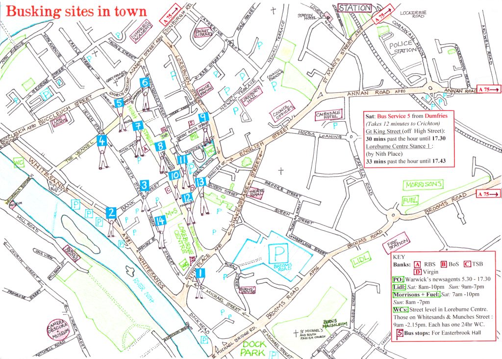
Below please find the proposed locations for the Street Singing on an Open User Map: click on the pin marker to reveal the Site Number, an image of the site, and the hot-linked What3Words location.
You can see the the proposed timetable by choir or by location. You can also download PDF versions from either timetable page.
Here is a handy table which lists Site Numbers, Name, and What3Words location:
| Site Number | Site Name | What3Words |
|---|---|---|
| 3 | Outside Yamas Deli, junction of Bank Street and Irish Street | ///beyond.whiplash.tape |
| 4 | Junction of The Vennel and Irish Street | ///gymnasium.fells.blazers |
| 5 | Church Place at Burn’s Statue | ///memory.cloud.handicaps |
| 6 | Outside Oxfam shop, junction of St Andrew’s Street and Queensberry Street | ///endearing.shrimp.hurt |
| 7 | Outside DGMA (was Debenhams) on High Street | ///roost.tortoises.reshaping |
| 8 | Queensberry Monument, High Street | ///veto.detective.factory |
| 10 | Plainstaines by Midsteeple | ///forces.strongman.thudding |
| 11 | Outside Change, off Queensberry and Munches Street | ///bounded.animator.bridge |
| 12 | The Fountain facing away from Plainstaines | ///javelin.exact.quietest |
| 13 | Outside T.B. Watson on English Street | ///apples.wheat.assorted |
| 14 | Inside Loreburn Centre outside M&S | ///tunes.overlaid.pins |
Please find through this Public Services link, an Open User Map with markers showing Public Toilets and a public water tap within reach of the Mass Sing at Dock Park and the Street Singing locations in the centre of Dumfries.